
UAV Operations · Geospatial Data

Emil Endres

I fly the missions, build the pipelines, and turn aerial data into decisions.

Drone operations and geospatial data specialist — from flight planning and automated docks to the software that turns aerial surveys into point clouds, elevation models, and decision-ready analytics.

Base 52.3989°N  0.2622°E
Sector Cambridge, UK
Platform DJI Matrice 3D / 4TD · M3M · M3T · Dock 2/3
What I do

Three disciplines, one workflow

Most drone work stops at capture. I own the whole loop — planning the flight, running the hardware, and writing the code that makes the data useful.

Flight Operations

Automated and crewed missions for large-scale survey work, planned for terrain, obstacles, and the data the analysis actually needs.

  • DJI Dock 2 / 3 deployment
  • WPML / KMZ mission generation
  • DTM-aware altitude & obstacle rules
  • UK CAA operational compliance

Geospatial Data

Turning raw imagery and point clouds into clean, decision-ready layers for analysts and operators.

  • OpenDroneMap on AWS GPU
  • CHM / DSM / DTM generation
  • Grid & line geometry pipelines
  • GeoJSON · GeoTIFF · LAS/LAZ

Software & Pipelines

Python tooling that ties capture to the dashboard — repeatable, documented, and built to run unattended.

  • Python · Shapely · GeoPandas
  • Interactive Plotly / Leaflet maps
  • S3 / EC2 processing workflows
  • Analytics dashboards
Selected work

Flight log

A flagship app, plus selected work across operations, data, and software.

Survey NOTAM & weather dashboard

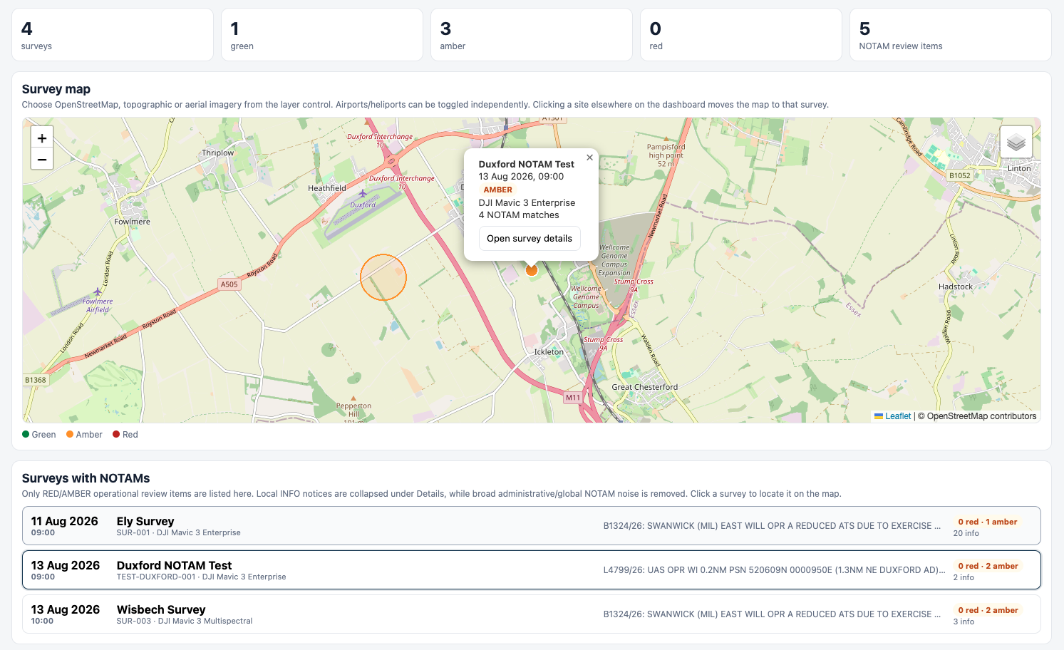
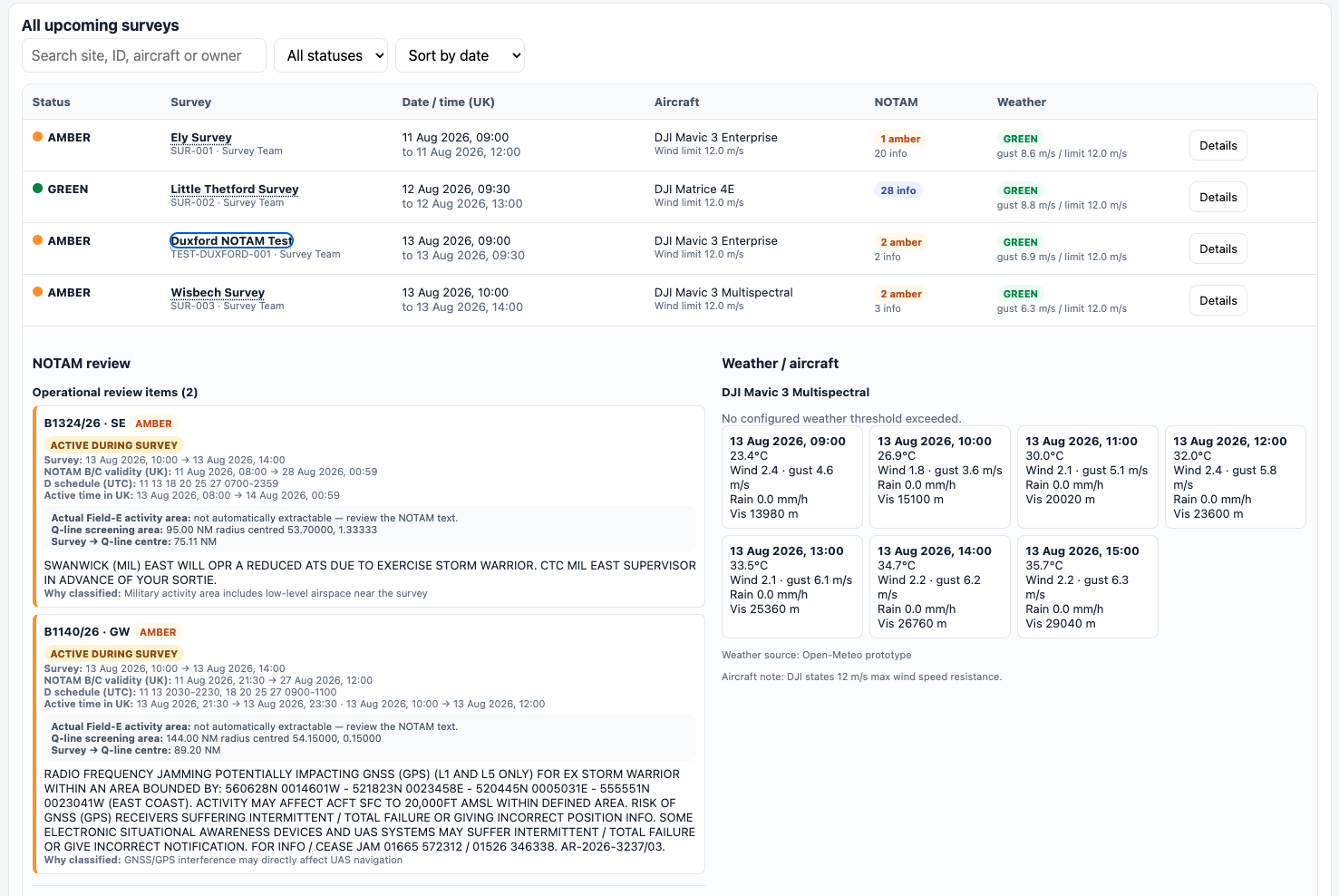
An automated pre-flight screen for a rolling survey schedule. It reads planned jobs and aircraft limits from a spreadsheet, screens the NATS UK NOTAM feed and hourly forecast against each site’s position, altitude and time window, and renders a self-contained dashboard with a traffic-light status per survey. A failed feed reports as data unknown, never green.

PythonNATS PIB XMLOpen-MeteoLeafletopenpyxl
Survey NOTAM dashboard — status metrics, Leaflet survey map with NOTAM activity area, and list of surveys with operational review items
Survey NOTAM dashboard — upcoming survey table with per-survey NOTAM review cards and hourly weather against aircraft wind limits

UAV RAMS automation system

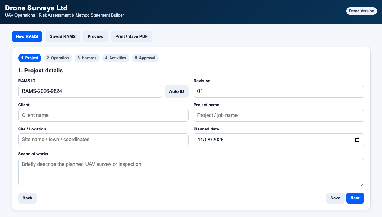
A browser-based operational safety application that generates site-specific UAV Risk Assessments and Method Statements from reusable hazard and control libraries, driven by conditional inputs about the operation. Risk scoring, revision control, an approval workflow, and print-ready PDF output — so a compliant RAMS for a new site is a few minutes of structured input rather than an afternoon of copy-paste.

PythonHTML5CSSJavaScript
UAV RAMS generator — project details step with RAMS ID, revision, client, site and scope of works fields

Automated site digitisation pipeline

A Python pipeline that fully digitises a site into discrete, addressable units — each carrying its own ID and attributes — turning a flat survey into a queryable, actionable dataset, accurate at any latitude.

PythonShapelyGeoPandasUTM

Cloud survey processing

End-to-end processing of aerial surveys on AWS GPU instances — parameter-tuned ground filtering, surface and elevation models, and an S3 workflow built to survive dropped SSH sessions.

OpenDroneMapAWS EC2DockerS3

Interactive analytics dashboard

An interactive dashboard with editable parameters, tier-based classification, live charts, and one-click Excel export — built so non-technical stakeholders can explore the numbers themselves.

JavaScriptFoliumChart.jsSheetJS

Terrain analysis

Interactive Plotly maps visualising slope, elevation, and aspect from GeoJSON and GeoTIFF DTM inputs — a clear read on site characteristics, block by block.

PythonPlotlyGeoTIFFNumPy

Waypoint Studio

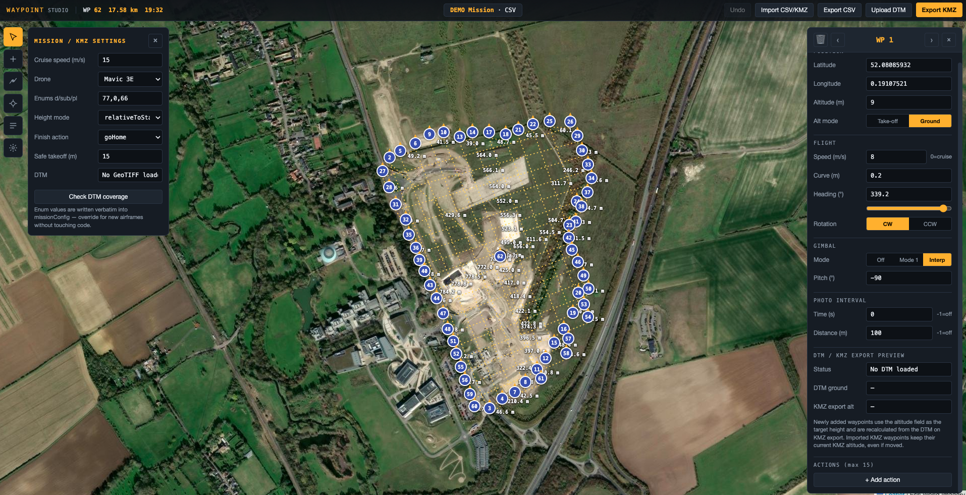
A browser-based mission-planning tool for building and editing drone flight paths — full CSV/KMZ round-trip, standards-compliant export, and a live map overlay, so complex routes can be designed, tuned, and shared without leaving the browser.

JavaScriptHTML5KMZ / WPMLLeaflet
Waypoint Studio — browser-based drone mission planner with map overlay and editable waypoint list

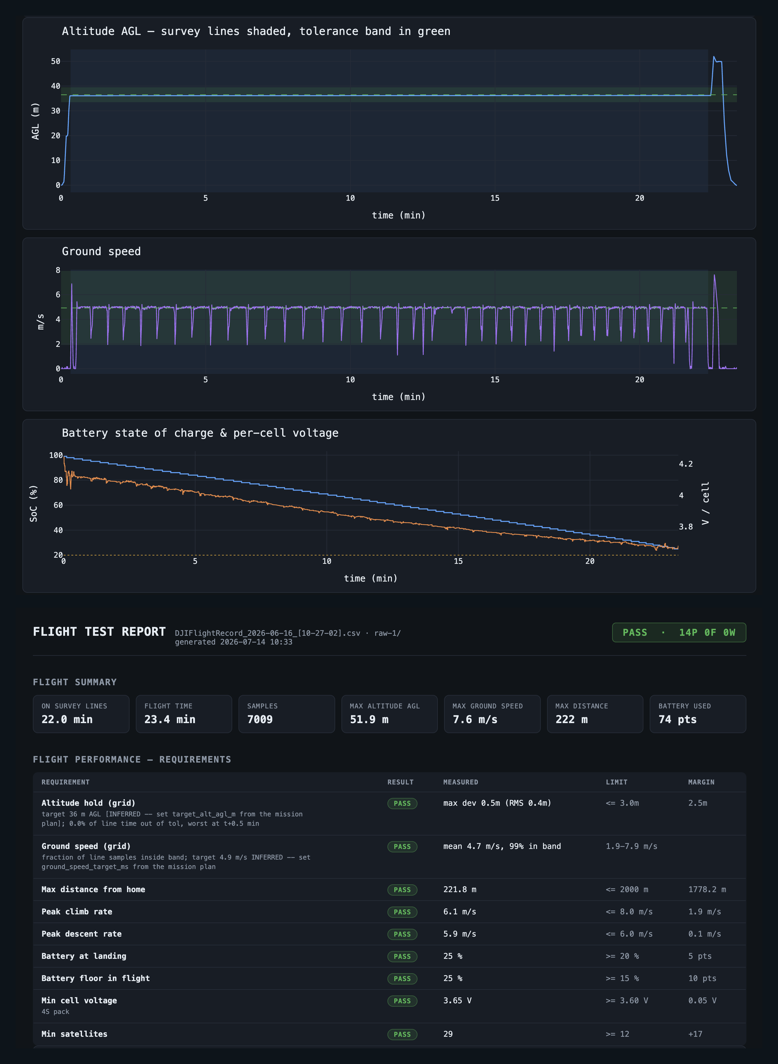
Flight Log & Performance Validation Suite

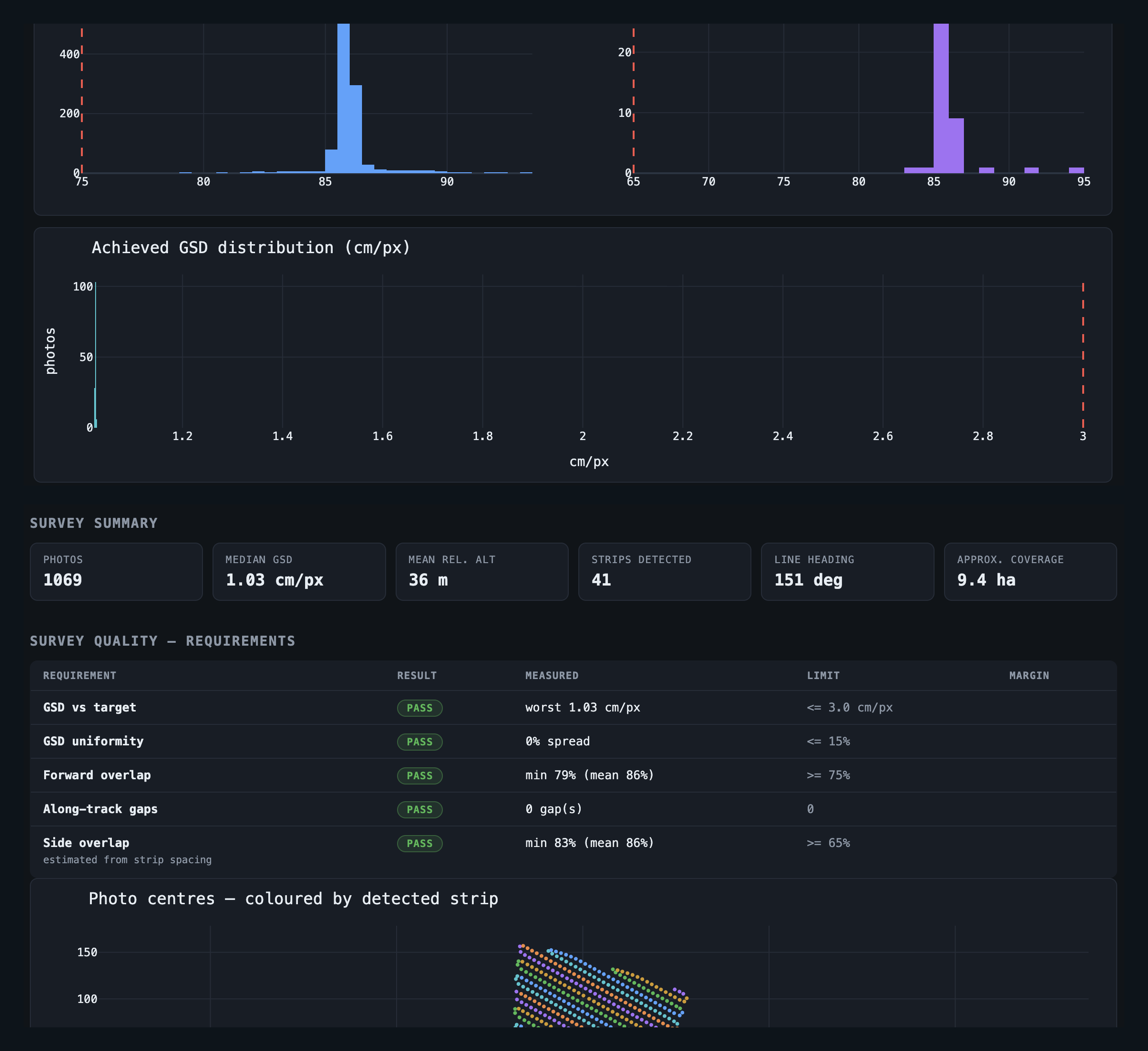
Tooling that parses raw flight logs and geotagged imagery into clear performance and data-quality reports — turning thousands of telemetry rows and photo records into an at-a-glance verdict on whether a flight met spec.

PythonPandasEXIF / XMPMatplotlib
Flight performance validation report — pass/fail requirements table and telemetry charts
Survey quality validation report — coverage summary, quality checks, and overlap distributions
Data delivery

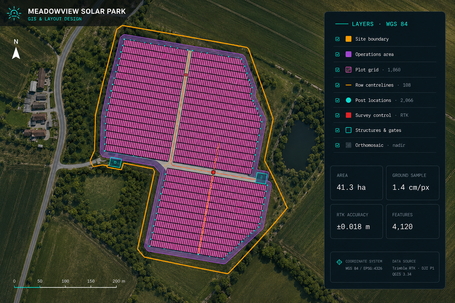
From RTK survey to GIS

A fully digitised dataset from a nadir, RTK-enabled survey — site boundary, operations area, a per-plot survey grid, row centrelines, post locations, and survey control, delivered as clean GIS layers in WGS 84. Illustrative site; all client data anonymised.

Anonymised GIS deliverable: digitised survey grid, operations area, post locations and orthomosaic for an illustrative solar park site
Field experience

Deployments

Survey and mapping operations across four very different regions.

52.2°N · 0.1°E

United Kingdom

Survey operations and pipeline development.

39.5°S · 176.8°E

Hawke's Bay, NZ

Aerial mapping campaigns across the region.

46.6°N · 120.5°W

Washington, USA

Autonomous dock deployment and high-accuracy terrain mapping.

34.9°S · 138.6°E

Australia

Drone survey operations.

43.5°N · 76.5°W

Upstate New York, USA

Survey operations near Lake Ontario.

46.5°N · 11.4°E

Bolzano, Italy

Alpine terrain survey and mapping.

47.4°N · 0.7°E

Loire Valley, France

Survey and mapping campaigns.

33.9°S · 18.9°E

Stellenbosch, South Africa

Survey, mapping, and R&D operations.

Credentials & stack

Certified & equipped

A2 Certificate of Competency (A2 CofC)UK CAA
Remote Pilot Certificate (Part 107)FAA
Certified DJI Dock 2 EngineerDJI
BSc Computer ScienceARU CAMBRIDGE
UK Operator ID & Remote IDCAA REG
PythonGeoPandasShapelyNumPy PlotlyLeafletFoliumOpenDroneMap AWS EC2S3DockerQGIS GeoTIFFGeoJSONLAS/LAZDJI WPML GitPyCharmLinux
Contact

Let's get something in the air.

Available for drone operations, geospatial consulting, and data-pipeline work. The best way to reach me is on LinkedIn.